


MARKETS
Rapid identification of the event location
Connectivity in areas with low coverage
Escalation from small incidents to large-scale operations, even across multiple sites
Provide up-to-date and visual information to managers who are off duty and need to come on board
Integration of any new tool with existing GIS
Incorporating smartphone cameras without the need for an APP
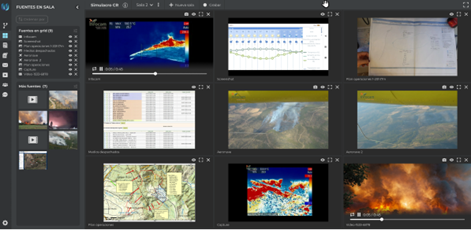
Real-time drone visualization at Command & Control room
Broadcast to a group of firefighters on the field involved in the operation
Real-time location of smartphones and drones
Integration with existing GIS tools via API
360° camera view of aerial, aquatic and/or ground vehicles
Daily sessions for easy, scalable and resizable management simultaneous events happen
Want to see more?
Floods
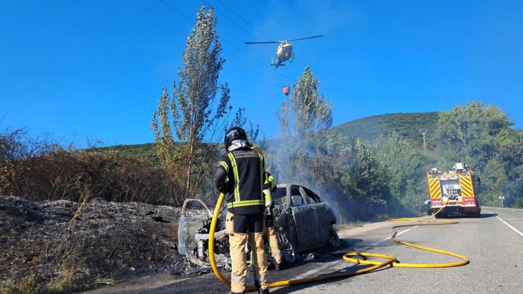
Forest fires
Industrial fires
Accidents
Search
Rescues
The Castilla-La Mancha Regional Government’s forest fire service (Infocam) entrusts Nuuk with the multimedia management of its firefighting coordination operations. The project focuses primarily on organizing multimedia information from aerial resources (helicopters, firefighting aircraft, drones, including 360-degree cameras) and mobile field devices. Flexcontrol helps evolving from simple initial management to the clustering of all the generated and geo-referenced multimedia information into different sessions and virtual rooms when the severity level increases (simultaneous fires).
Complete Success Story
You can download the full Success Story by submitting your request using this form.
Necessary cookies are absolutely essential for the website to function properly. These cookies ensure basic functionalities and security features of the website, anonymously.
| Cookie | Duration | Description |
|---|---|---|
| cookielawinfo-checbox-analytics | 11 months | This cookie is set by GDPR Cookie Consent plugin. The cookie is used to store the user consent for the cookies in the category "Analytics". |
| cookielawinfo-checbox-functional | 11 months | The cookie is set by GDPR cookie consent to record the user consent for the cookies in the category "Functional". |
| cookielawinfo-checbox-others | 11 months | This cookie is set by GDPR Cookie Consent plugin. The cookie is used to store the user consent for the cookies in the category "Other. |
| cookielawinfo-checkbox-advertisement | 1 year | The cookie is set by GDPR cookie consent to record the user consent for the cookies in the category "Advertisement". |
| cookielawinfo-checkbox-necessary | 11 months | This cookie is set by GDPR Cookie Consent plugin. The cookies is used to store the user consent for the cookies in the category "Necessary". |
| cookielawinfo-checkbox-performance | 11 months | This cookie is set by GDPR Cookie Consent plugin. The cookie is used to store the user consent for the cookies in the category "Performance". |
| viewed_cookie_policy | 11 months | The cookie is set by the GDPR cookie consent plugin and is used to store whether or not the user has consented to the use of cookies. It does not store any personal data. |
Other uncategorized cookies are those that are being analyzed and have not been classified into a category as yet.
| Cookie | Duration | Description |
|---|---|---|
| cookielawinfo-checkbox-funcionales | 1 year | No description |
| cookielawinfo-checkbox-necesarias | 1 year | No description |
| cookielawinfo-checkbox-otras | 1 year | No description |
| HappyLocalTimeZone | session | No description |
| wp-wpml_current_language | 1 day | No description |
Functional cookies help to perform certain functionalities like sharing the content of the website on social media platforms, collect feedbacks, and other third-party features.
| Cookie | Duration | Description |
|---|---|---|
| _icl_visitor_lang_js | 1 day | This cookie is stored by WPML WordPress plugin. The purpose of the cookie is to store the redirected language. |
| wpml_browser_redirect_test | session | This cookie is set by WPML WordPress plugin and is used to test if cookies are enabled on the browser. |
Analytical cookies help web page owners understand how visitors interact with web pages by gathering and information anonymously.
| Cookie | Duration | Description |
|---|---|---|
| _ga | 2 years | This cookie is installed by Google Analytics. The cookie is used to calculate visitor, session, campaign data and keep track of site usage for the site's analytics report. The cookies store information anonymously and assign a randomly generated number to identify unique visitors. |
| _ga_BGRSJJ6SZ0 | 2 years | No description |